Gresten and Gresten-Land:
The Geography of the Hasselbachers of Austria.
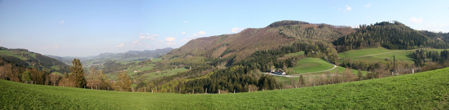
I traveled to Germany in April, 2008, and had an opportunity to visit Gresten, Austria. This was my first visit to the oldest known ancestral home of my Hasselbachers. I had only 2 half-days, and despite one rainy morning it was a wonderful introductory experience. It would not have been nearly so had I not been met and escorted by the former mayor and his colleague who both have a special interest in the old history of Gresten and its Exulanten. My introduction to these gentlemen was made by the Gesellschaft für Familienforschung in Franken in Nürnberg that I joined two years ago. Once again, I benefited from the kindness of strangers. (I used to refer to this phenomenon as the unexpected kindness of strangers but I now have the confidence to drop the “unexpected” label from what seems to be the norm rather than the exception!) I learned much and gathered a good bit of information requiring translation and analysis, but there is much more to be unearthed. Part of the area around Gresten is administratively called "Gresten-Land", a term appearing on old maps. This includes the district called “Schadnerampt.” [See map.] The farms and locations to which we have the earliest references of Hasselbachers are not in the village of Gresten proper, but in the adjacent, wide, U-shaped valley that rises just to the west of the village. Although there may have been ancient glacial forces that originally carved it, it was also shaped by the small Grestenbach stream that flows down into the Kleinen Erlauf River of Gresten. The valley is referred to as the Grestenbachgraben. (Topo Map) A road rises from the village up the floor the graben, but it is on the high western crest where the houses and farms linked to the Hasselbachers were located and can still be found. (More detailed map with farm locations.) The photo above was taken from the top of the graben and looks east towards Gresten which can be seen in the distance. A former page with old Postcards of the Village has been moved. The valley rises from an elevation of about 418 m in Gresten Village to just over 800 m on the tops of the enclosing hills: Grestenberg on the north and Buchberg on the south. Going westward up the graben from Gresten through Schadnerampt, the traveler passes over a saddle-shaped pass at about 640 m into a somewhat narrower and steeper valley that faces westwards towards the village of Ybbsitz. This valley is the Haselgraben and it is shaped by a small stream named on some maps as the Haselgrabenbach, or alternatively by local residents, the Haselbach. A house called Haselbach is still located on crest of this valley. It is my hypothesis that these lands lent us our family name. I was profoundly struck by the fact that the farms to which the names of our ancient relatives were associated are still physically present. Places where Hasselbachers lived. Letters correspond to aerial photo.: (Click the Name link above to see photos of the present farm structures.) Indeed, I could identify only a handful of farm locations or buildings on that hillside that were not already present four hundred years ago. I was profoundly impressed with the sense of having stepped backwards in time. I felt I was seeing virtually the same things that Stephan and his son Wolfgang Hasselbacher would have seen in the early 1600s. (Here is a Map from 1845.) This place is laced with history. The roads and houses contain old historical markers with stories of people and events of early times. I photographed those I saw but their lessons will require translation. I also assembled a Short Video of the area. As is true for this site generally, you will need a QuickTime Plug-in for your browser in order to view it. For those without, or with connection problems, I posted a lower resolution and somewhat shorter version privately on YouTube. If you are still having trouble, we can arrange to mail you a CD with the large (272 MB) file. I will continue posting photographs of the farmhouses and views of the valley from their yards. Some of the Gresten records that name these locations are summarized elsewhere on this site. I will also post some original images and a report and transcriptions of the original records by a Gresten teacher, Leopold Schöberl. Please check back. Addendum 11-20-08. I found a wonderful video taken by Hubert from a radio-controlled model glider. Because the take-off point was from the model-airplane runway at Gseng, it shows exactly the area we are interested in. Here is the link from You-Tube.When I have a little time, I will make a timeline to help you identify what you are seeing at what moment. Peter Hasselbacher |